
Walk 40: Newport to Cardigan
- Oct 14, 2025
- 4 min read
Having spent the best part of 2023 gradually walking the Pembrokeshire Coast Path, we had finally reached the big one – our last in Pembrokeshire, and widely regarded as the most challenging walk of the Wales Coast Path – Newport to Cardigan.

I’d been slightly dreading this one, as I knew it would be rugged, remote, and with lots of ups and downs – over 3,000 feet of ascent, in fact – but we made sure to set ourselves up for success by picking a day with good walking weather, packing plenty of water and food, wearing our most comfortable shoes and forming an escape plan just in case anything went wrong!

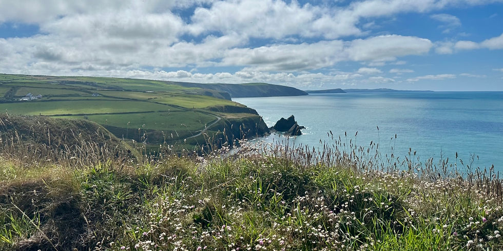
We began the day by driving to Cardigan and catching the bus to Newport. We walked from our stop to the bridge where we’d finished our previous walk, and took the Pembrokeshire Coast Path alongside the estuary, with lovely views back towards Newport.

The path took us through Newport Links Golf Club and past the stunning beach, before we reached a gate with a warning – that past the gate lay a 12.8-mile walk to Poppit Sands with no facilities. Thankfully, we were well prepared, so we continued onwards along the coastal path. We enjoyed pretty easy walking for a while, before taking on the first of many climbs as we headed down a hill, across a bridge over a stream, and then back up quite a few steps.

Our next steep climb was improved by the sight of a few hares – always a treat as, as bunny guardians, we’re particularly fond of rabbits and hares. When we reached the top, we turned back to find the most incredible views – this was a lovely, mountainous-feeling section with lots of gorse and views of Newport Sands.

We continued along with much the same – stunning views, ups and downs, and generally good walking weather – there was a bit more sunshine than absolutely ideal and we did get a bit of a sweat on, but we were very glad to avoid any rain!

At one point was we walked, we noticed a couple of wild ponies. There wasn’t room on the path to pass them, so instead, they walked in front of us for a little while before reaching a passing point, where they very kindly let us pass!

We soon reached the Witches’ Cauldron – a collapsed sea cave known for its green waters and the way the sea ‘bubbles’ as it rushes through the tunnel to the beach on the other side. We took the steep walk down towards it, and were surprised to see that it was actually quite busy, with plenty of people having taken the walk from Ceibwr Bay.

The path takes you over the tunnel, which means you can enjoy lovely sea views to your left and right, before continuing onwards. The section from the Witches’ Cauldron to Ceibwr Bay was really enjoyable, with the visitors heading along the path giving this section a bit of a buzz which contrasted with the quiet of the rest of the path.

When we reached Ceibwr Bay, we were ready for some lunch, so we stopped off for a sandwich and spotted a seal bobbing around in the sea as we ate. This would have been our opportunity to leave the path and head towards a bus stop if we didn’t think we could finish the walk, but we were fine to continue, so we headed back up from the sea and onto the cliffs once again.

Aside from my knees getting a bit upset with me during the descents, I still felt pretty good as we continued to navigate the ups and downs. As we headed towards Cemaes Head, we even spotted some seals on the beach below.
As we reached Cemaes Head, the most northerly headland on the Pembrokeshire coast, we knew we were on the home strait. This was a really pretty moorland section and, as we rounded the headland, we enjoyed beautiful views of Poppit Sands.

As we headed down towards Poppit Sands, we spotted an iron border with the title ‘Pembrokeshire Coast Path Gate No1’. We hadn’t spotted any other gates on our walk – I wonder where they were hiding!

We had considered stopping for a swim at Poppit Sands, but we were ready for some food, so continued along the road towards St Dogmaels, enjoying pretty estuary views as we went. With just a short distance to Cardigan, we stopped off at Môr Ffein for some chips and curry sauce before taking on the final stretch.

Officially, the Wales Coast Path detours through farmland here, but I had read that there were some fields with cows along the way and I couldn’t bear the thought of having to turn back at this late stage, so we walked along the road, which was actually closer to the estuary than the fields were.

We finally crossed the bridge into Cardigan – officially now out of Pembrokeshire and in Ceredigion! We walked to the car and headed back to our holiday cottage, with the Pembrokeshire Coast Path officially ticked off!
So what did I think of the most difficult walk of the Wales Coast Path? While it's not to be underestimated, as long as you’re well prepared and have a decent level of fitness, I think it’s a wonderful walk!
🥾 Distance: 17 miles. ⭐ Highlight: Just so many beautiful views! 👎 Less Good: There weren’t any specific lowlights, but it is a difficult walk. 🚗 Transport: We parked in Cardigan, caught the bus to Newport and walked back to the car! 🛏️ Accommodation: We had a lovely two-week stay in a pretty cottage in Lower Fishguard. 🌱 Food: We had some chips and curry sauce at Môr Ffein in St Dogmaels. 🗺️ Map: This route is featured in the official Pembrokeshire guide. |
Still not convinced? Read my ten reasons to walk the Wales Coast Path. If you’re ready to start planning your walk, you can find lots of resources to help you on your way here. Please note, I collect a share of the sales from the links on this page.


